Anchored by the city of Toronto’s emergence as a leading world financial and business centre, the Greater Golden Horseshoe has experienced very high population growth rates in recent years. As such growth has occurred, however, the need for a unified regional land use plan was soon recognized. This recognition was codified through the Ontario Growth Plan (OGP), which was first released in 2006 but has been continually modified since then (with the last major update occurring in 2020).

The implementation of this plan has had visible effects at both the regional and international levels. With a greater focus on land use policy, municipalities and businesses are lining up to ensure that they have the best technology at their disposal. Render Developments is proud to provide their clients with mapping and imaging services that allow them to adhere to and build upon the policies outlined in the OGP. The fact that the Toronto region now has such a plan is indicative of not only an expectation that its high rates of growth will continue, but also an awareness that its role as a global economic node is predicated in managing the ways in which that growth makes use of the region’s land. As a result, the decision to have a unified growth plan puts the Greater Golden Horseshoe in the company of many of North America’s most prominent metropolises. While the specific aim and scale of each plan differs depending on the local and regional context (especially between US and Canadian cities), the overall intentions are similar: to ensure the management of land in a way that is both sustainable and accommodating of both present and future population growth.
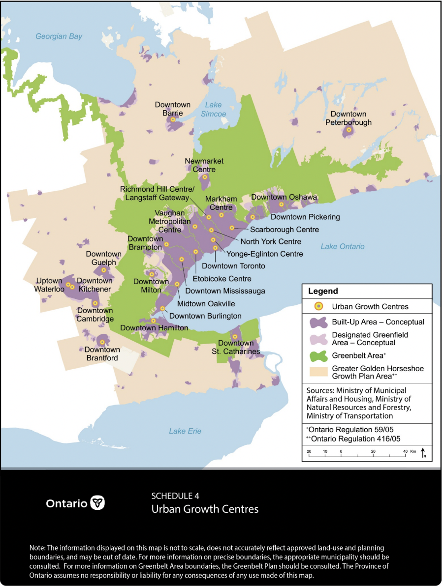
The Ontario Growth Plan: An Embrace of Polycentrism
A core part of the Ontario Growth Plan (or OGP) is its provision for a series of nodes, termed “Urban Growth Centres”, in locations throughout the Toronto region. While Downtown Toronto would continue to serve as the region’s main economic hub and a prime residential location, it would be supplemented by increased residential growth and commercial or industrial activity in the Urban Growth Centres. This form of urban development is commonly known as polycentrism. Under this system, a region has multiple economic and cultural hubs throughout the metropolitan region. This stands in contrast to monocentrism, in which a city-region has one centre that serves as the main hub for the entire metropolitan area. In its purest form, each node under a polycentric model would have equal clout relative to others in its urban region. While regions based around hubs of relatively equal importance can be found in some major North American metropolitan areas (such as Dallas and Fort Worth in Texas, or Minneapolis and St. Paul in Minnesota), the more common model is a central downtown core and a set of smaller – but still important – nodes. This model is present in locations such as the San Francisco Bay Area ( Silicon Valley and the Downtown Oakland area serve as secondary central business districts to Downtown San Francisco) and Metro Vancouver (Coquitlam Town Centre, the Metrotown area and other districts are important economic and cultural hubs, but Downtown Vancouver is still the most important locale for such activities). It is this model that the OGP hopes to emulate, with Downtown Toronto continuing to serve as the region’s central node, but with the Urban Growth Centres serving as satellite ones scattered throughout the region. One such secondary node is centred on Downtown Oshawa and its surroundings. Due to the presence of a strong existing commercial and industrial base, the city is poised for future growth as an Urban Growth Centre. Through the creation of a virtual tour for the rapidly-growing Northwood neighbourhood, Render Developments is pleased to have been able to work closely with the Oshawa municipal government as they seek future investment.
While most North American cities have citywide urban planning and land use strategies, regional plans in the style of the OGP are less common in the United States. A major reason for the U.S. having fewer such plans is the different ways that land use is administered in each country. In Canada, the Constitution Act gives the province the power to enact and enforce laws related to land use and development. Because this is the case, land use plans at the regional level are more commonly found in Canadian urban areas because the government body in charge of creating such plans is inherently more concerned with issues at the regional level than at the municipal one. As a result, regional plans similar to the OGP can be found in locations across Canada, such as Vancouver’s Metro 2050 plan and the Calgary Metropolitan Region Board’s growth plan. In the U.S., much of the power regarding land use lies at the city or municipal level, making cooperation between municipalities more difficult. While regional agencies are present in various locations (particularly in regards to airport management) in major American cities, they are nowhere near as prevalent or as powerful. Exceptions to this rule exist, however, with the most notable being California. Under that state’s law, cities and counties are each required to create a plan (normally referred to as a general plan) that governs their development objectives. While not approaching the scale of regional planning that is found in Canada, the requirement that counties create a plan as well does emphasize the need for a plan that transcends the boundaries of individual cities. Los Angeles County, for example, currently has a population that, as of 2021, approaches the level of the entire Greater Golden Horseshoe. While comprising only a portion of the entire Los Angeles metropolitan area, the fact that such a large number of people live under the jurisdiction of the county’s general plan arguably gives it just as much importance as the OGP.
Looking to the Future
As cities around North America make plans to combat the interlinked challenges related to population growth and climate change, the methods through which land use management is planned and coordinated matters more than ever. While the goals and priorities vary from location to location, it is clear that major differences between approaches can be found on either side of the U.S.-Canada border. With Canada’s land use policymaking is concentrated at the provincial level, initiatives such as the Ontario Growth Plan are designed at the regional level rather than individual cities each setting their own agenda (as is more commonly the case in the U.S. – though the recently-enacted “strong mayor” policies may make it more common in Ontario). Each approach has positives and negatives, yet both offer a way forward in the fight against climate change and the management of population growth.